Issued at 4.45pm 23rd May for 25th & 26th May 2024
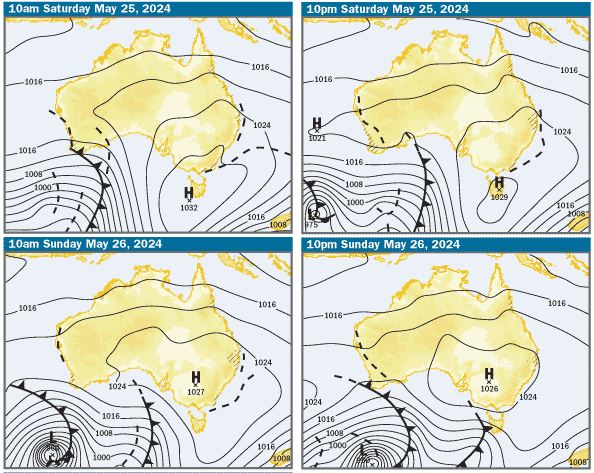
Charts: The charts are indicating that on Saturday and Sunday, there’ll be a slow moving high pressure system centred over western NSW and extending a ridge along the Qld coast, creating SE winds
There’s also a weak trough laying along the southern Qld and Northern NSW coasts and extending into the Tasman Sea. This trough looks like it washes out through the day on Sunday. On one hand, it will erode the ridge of high pressure along the southern Qld and Northern NSW coasts and help keep the SE winds light to moderate and on the other hand, trigger showers
SE Qld Weather Outlook: Based on what the charts are showing, in offshore waters, it looks like there’ll be 10-15kts SE winds on Saturday, easing a little overnight and 10-15kts S/SE winds on Sunday. There’s a high chance of showers on both days
On Moreton Bay, there should be light S/SW land breezes inshore early, swinging 10-15kts S/SE during the days. They should ease a little and swing back to the S/SW on Saturday night and there’s a high chance of showers on both days
Tides & Moon: It was full moon last night and on the weekend, there should mid to late morning highs and afternoon lows. Around full and new moons, tidal differences increase and at this time of year the biggest tides are at night. Click this link for precise tide times and heights at various locations
Swell & Coastal Bars: The swell has been small and lacking power for much of this week and is expected to continue like that on the weekend. Expect it to be 0.75m E/SE on the bars and crossing them looks like it’ll be pretty safe. However, still take care doing that, as it’s surprising how many bar mishaps happen on good days. Take extra care on the afternoon ebb tides, as when the water runs out through narrow bar channels, it can create pressure waves, which are bigger than swell size and break unpredictably
Sailing & Boating: Based on the weather predictions, apart from a high chance of showers which will mean taking wet weather gear, it’s looking pretty good for sailing. Boating conditions in offshore and open bay waters should be a little choppy, but comfortable in small boats. As always, the best cruising and anchorages will be along the western sides of Moreton and North Stradbroke Islands, in the sheltered waters from Caloundra to Toorbul in Pumicestone Passage, the southern bay from Peel Island to the northern parts of Southport Broadwater and in the rivers and creeks
Fishing: Based on the weather predictions, it looks like it’ll be workable for fishing in offshore and open bay waters in small boats, on the dams in SE Qld and in the estuaries, rivers and creeks. To help you plan your weekend angling, the latest SE Qld Fishing Report was published on the Coastwatch web site this afternoon
Surf: Expect the swell to be about 0.75m E/SE along the northern ends of the Sunshine and Gold Coasts and along the Tweed Coast and a bit smaller in the bays on the north side of headlands. Given the forecast for S/SW winds early, look for beach breaks between Maroochydore and Caloundra and from Currumbin to Coolangatta. When the winds swing S/SE, the points and bays on the north side of headlands will have the cleanest conditions, but waves will be small. You can check the latest surf conditions with the daily Surf Report published about 5.50 every morning
Beach: The weather outlook indicates a high chance of showers and cool SW/SE winds, so not great beach weather. The bays on the northern side of the headlands at Noosa, Mooloolaba, Burleigh, Kirra, Greenmount and Rainbow Bay will offer the best shelter from those winds. Along the open stretches of beach there’s inshore holes and gutters and on the afternoon ebb tides, any rips working around those features will be enhanced as the water drains off the beach, so swim in the patrolled areas marked by the red and yellow flags. For the latest beach conditions, check our daily Beach Report published about 5.50 every morning

More Articles
COASTAL WEATHER OUTLOOK for Qld — March 6th, 7th, 8th 2026
Issued 6:45pm, March 5th. A turbulent few days are ahead for much of the Queensland coastline, with a developing tropical low, strengthening troughs, and shifting wind patterns shaping conditions ...
COASTAL WEATHER OUTLOOK for South East Qld — February 5th
Boaters across southeast Queensland and northeastern New South Wales can expect generally calm conditions this weekend, with light winds, low swell and no rain or storms forecast.