Byron Coast
Byron Coastal Waters: Point Danger to Wooli Forecast
By the Bureau of Meteorology
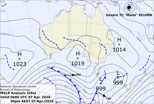
Today’s weather chart
Byron Coastal Waters: Point Danger to Wooli Forecast
By the Bureau of Meteorology
A high pressure ridge extends over the state's north, while a trough is moving up the southern and central parts of the coast as a southerly change today through to early Wednesday. The trough will weaken as another ridge drifts across the coastal waters midweek. Then, a strong cold front is forecast to moves across the coastal waters later in the week and into the weekend, with a fresh and gusty southerly wind change in its wake.
Forecast issued at 04:42 am EST on Tuesday 07 April 2026.
Warnings Current
Marine Wind Warning Summary for New South Wales
IDN20400
Australian Government Bureau of Meteorology
New South Wales
Marine Wind Warning Summary for New South Wales
Issued at 6:26 PM EST on Tuesday 7 Apr 2026.
Wind Warnings for Tuesday 7 Apr
Strong Wind Warning for the following areas
Eden Coast
Wind Warnings for Wednesday 8 Apr
Strong Wind Warning for the following areas
Eden Coast
The next marine wind warning summary will be issued by 10:00 pm EST Tuesday.
Check the latest Coastal Waters Forecast or Local Waters Forecast at http://www.bom.gov.au/nsw/forecasts/map.shtml for information on wind, wave and weather conditions for these coastal zones.

Forecast for Tuesday until midnight
| Wind | Northerly 10 to 15 knots, reaching up to 20 knots inshore in the evening. |
| Seas | Around 1 metre. |
| Swell | Easterly around 1 metre. |
| Weather | Clear. |
Wednesday 08 April
| Wind | North to northwesterly 10 to 15 knots tending north to northeasterly in the late morning and afternoon. Winds reaching up to 20 knots north of Yamba in the evening. |
| Seas | Around 1 metre. |
| Swell | Southerly around 1 metre. |
| Weather | Sunny. |
Thursday 09 April
| Wind | Northerly 10 to 15 knots turning northeasterly in the middle of the day. |
| Seas | Around 1 metre. |
| Swell | Easterly around 1 metre, increasing to 1 to 1.5 metres during the morning. |
| Weather | Mostly sunny. |
Friday 10 April
| Wind | Northerly 15 to 20 knots. |
| Seas | Around 1 metre, increasing to 1 to 1.5 metres south of Cape Byron during the afternoon or evening. |
| Swell | Easterly 1.5 metres, increasing to 1.5 to 2 metres during the morning. |
| Weather | Mostly sunny. |
Current Weather
Latest BOM Weather Stations Data
Anemometer Location: Lat -28.64 Lon 153.636. 95 m above sea level.
- Wind NNW 12kts
- Gusts 15kts
- Temp 23.8°C
- Rain 18:00pm 0mm
Anemometer Location: Lat -28.835 Lon 153.559. 1.3 m above sea level.
- Wind NNE 7kts
- Gusts 8kts
- Temp 22.9°C
- Rain 18:00pm 0mm
Anemometer Location: Lat -28.83 Lon 153.26. 9.21 m above sea level.
- Wind NE 9kts
- Gusts 10kts
- Temp 23.1°C
- Rain 18:00pm 0mm
Anemometer Location: Lat -28.168 Lon 153.505, Airport. 1 m above sea level. 6km from coast.
- Wind N 11kts
- Gusts 13kts
- Temp 24.4°C
- Rain 18:00pm 0mm
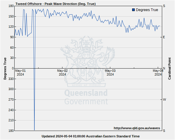
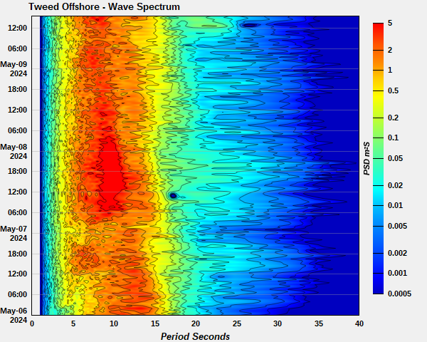
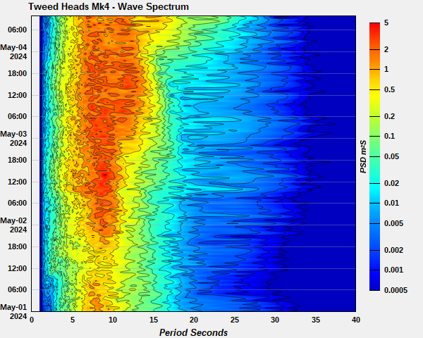
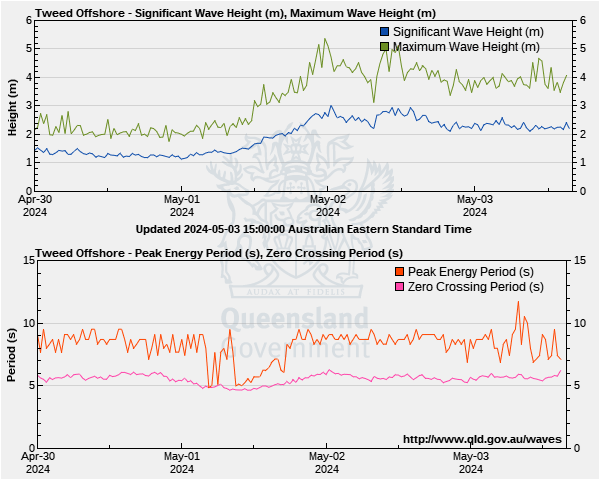
Byron Coastal Waters: Point Danger to Wooli Wave Buoys
Lat: 28°10'39.3"S
Lon: 153°34'35.6"E
Water depth: 22 m
Source: Queensland Government (Department of Environment, Science and Innovation).
Wave height & period
On the Wave Height graph, the blue line shows the swell most indicative of what you will encounter in offshore waters
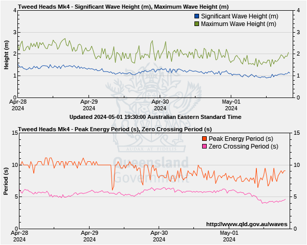
On the Peak Energy period graph which shows time between swells, the pink line is most indicative of what you will encounter in offshore waters
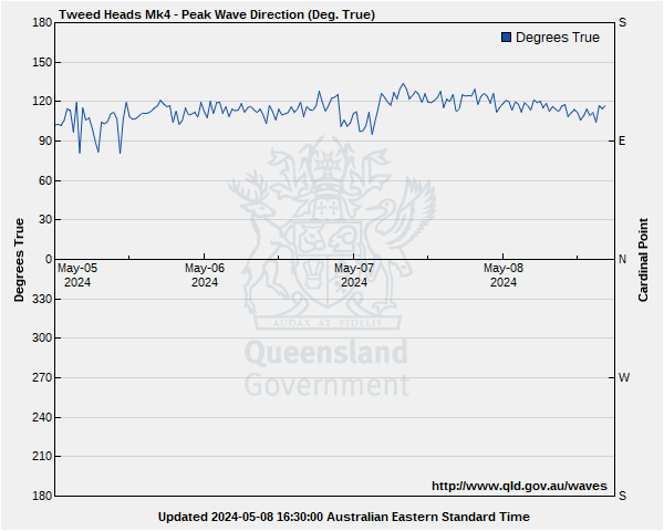
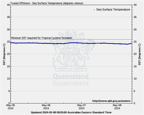
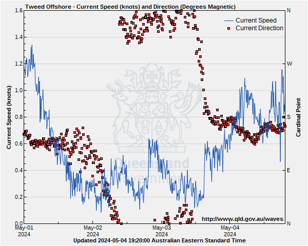
Lat: 28°12'45.2"S
Lon: 153°40'48.6"E
Water depth: 60 m
Source: Queensland Government (Department of Environment, Science and Innovation).
Wave height & period
On the Wave Height graph, the blue line shows the swell most indicative of what you will encounter in offshore waters
On the Peak Energy period graph which shows time between swells, the pink line is most indicative of what you will encounter in offshore waters