Moreton Bay
Moreton Bay Forecast
By the Bureau of Meteorology
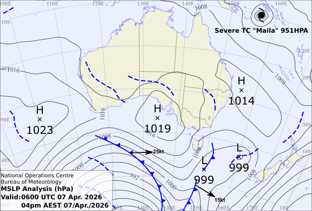
Today’s weather chart
Moreton Bay Forecast
By the Bureau of Meteorology
Two highs over the Tasman Sea and Victoria extend a weak ridge over the south Queensland waters.
Forecast issued at 06:02 am EST on Tuesday 07 April 2026.
Warnings Current
Marine Wind Warning Summary for Queensland
IDQ20085
Australian Government Bureau of Meteorology
Queensland
Marine Wind Warning Summary for Queensland
Issued at 6:26 PM EST on Tuesday 7 Apr 2026.
Wind Warnings for Wednesday 8 Apr
Strong Wind Warning for the following areas
Cooktown Coast and Cairns Coast
The next marine wind warning summary will be issued by 9:00 pm EST Tuesday.
Check the latest Coastal Waters Forecast or Local Waters Forecast at http://www.bom.gov.au/qld/forecasts/map.shtml for information on wind, wave and weather conditions for these coastal zones.
Minor Flood Warning for the Thomson River and Cooper Creek
IDQ20860
Australian Government Bureau of Meteorology
National Water Operations
Minor Flood Warning for the Thomson River and Cooper Creek
Issued at 12:10 AM AEST on Tuesday 7 Apr 2026.
Flood Warning Number: 97
MINOR FLOODING IS EASING AT JUNDAH AND WINDORAH
The flood peak is downstream of Windorah, along the Cooper Creek. River levels upstream of Windorah are continuing to fall.
Thomson River
Minor flooding is easing at Jundah, and is no longer occurring at Stonehenge.
Cooper Creek
Minor flooding is easing at Windorah.
Latest River Heights
| Location | Height of River (m) | Tendency | Date/Time of Observation |
|---|---|---|---|
| Cornish Creek at Bowen Downs | 1.38 | steady | 9:00 am Tue 07/04/26 |
| Thomson River at Muttaburra | 1.03 | steady | 12:00 pm Tue 07/04/26 |
| Thomson River at Longreach | 1.46 | steady | 9:00 am Tue 07/04/26 |
| Thomson River at Bogewong | 1.69 | steady | 12:00 pm Tue 07/04/26 |
| Thomson River at Jundah | 3.17 | falling | 7:00 am Tue 07/04/26 |
| Jordan Creek at Glencoe | 0.79 | steady | 9:38 am Tue 07/04/26 |
| Alice River at Barcaldine Weir | 4.65 | steady | 9:00 am Tue 07/04/26 |
| Barcoo River at Retreat | 1.32 | steady | 9:00 am Tue 07/04/26 |
| Cooper Creek at Windorah (Lignum Channel) | 0.12 | steady | 12:00 pm Tue 07/04/26 |
| Cooper Creek at Windorah | 4.31 | falling | 6:30 am Tue 07/04/26 |
| Cooper Creek at Nappa Merrie | 2.11 | steady | 9:00 am Tue 07/04/26 |
Major Flood Warning for the Eyre Creek and Minor Flood Warning for the Georgina River
IDQ20870
Australian Government Bureau of Meteorology
National Water Operations
Major Flood Warning for the Eyre Creek and Minor Flood Warning for the Georgina River
Issued at 12:01 AM AEST on Tuesday 7 Apr 2026.
Flood Warning Number: 69
MAJOR FLOODING EASING SLOWLY AT GLENGYLE
MODERATE FLOODING EASING SLOWLY AT BEDOURIE
River levels are continuing to fall along the Georgina River and Eyre Creek.
Georgina River to Marion Downs
Minor flooding is easing at Marion Downs.
Georgina River downstream of Marion Downs
River levels continue to fall along the Georgina River downstream of Marion Downs.
Eyre Creek
Major flooding is easing at Glengyle and moderate flooding is easing at Bedourie.
Latest River Heights
| Location | Height of River (m) | Tendency | Date/Time of Observation |
|---|---|---|---|
| Georgina River at Roxborough Downs Tm | 3.17 | steady | 9:00 am Tue 07/04/26 |
| Burke River at Boulia | 1.62 | steady | 9:00 am Tue 07/04/26 |
| Georgina River at Marion Downs | 3.55 | steady | 9:00 am Tue 07/04/26 |
| Eyre Creek at Bedourie | 4.67 | steady | 9:00 am Tue 07/04/26 |
| Eyre Creek at Glengyle | 4.20 | steady | 9:00 am Fri 03/04/26 |
Moderate Flood Warning for the Lower Diamantina River
IDQ20865
Australian Government Bureau of Meteorology
National Water Operations
Moderate Flood Warning for the Lower Diamantina River
Issued at 11:21 AM AEST on Tuesday 7 Apr 2026.
Flood Warning Number: 81
BIRDSVILLE LIKELY TO PEAK AROUND THE MODERATE FLOOD LEVEL FROM THURSDAY 9 APRIL
Minor flooding is continuing between Monkira and Durrie Station. Downstream, the main flood peak is currently around Roseberth Station, where major flooding is nearing a peak. Minor flooding is continuing at Birdsville, where the river level is rising slowly, with a peak around the moderate flood level likely from Thursday 9 April.
Diamantina River downstream of Diamantina Lakes
Major flooding is nearing a peak at Roseberth Station. Minor flooding is occurring at Durrie Station and Birdsville.
Latest River Heights
| Location | Height of River (m) | Tendency | Date/Time of Observation |
|---|---|---|---|
| Mills Creek at Oondooroo | 1.27 | steady | 9:00 am Tue 07/04/26 |
| Diamantina River at Diamantina Lakes Tm | 1.03 | steady | 9:00 am Tue 07/04/26 |
| Diamantina River at Monkira | 2.60 | falling | 9:00 am Tue 07/04/26 |
| Diamantina River at Durrie Station | 1.85 | steady | 9:00 am Tue 07/04/26 |
| Diamantina River at Roseberth Station | 5.25 | steady | 6:50 am Tue 07/04/26 |
| Diamantina River at Birdsville Police Station | 5.75 | rising | 9:00 am Mon 06/04/26 |
| Diamantina River at Birdsville | 6.27 | rising | 10:10 am Tue 07/04/26 |

Forecast for Tuesday until midnight
| Wind | Northerly 10 to 15 knots decreasing to about 10 knots in the late evening. |
| Seas | Below 1 metre. |
| Weather | Clear. |
Wednesday 08 April
| Wind | North to northwesterly about 10 knots tending north to northeasterly 10 to 15 knots in the middle of the day. |
| Seas | Below 1 metre. |
| Weather | Sunny. |
Thursday 09 April
| Wind | Variable about 10 knots. |
| Seas | Below 1 metre. |
| Weather | Mostly sunny. |
Friday 10 April
| Wind | Variable below 10 knots. |
| Seas | Below 1 metre. |
| Weather | Mostly sunny. |
Current Weather
Latest BOM Weather Stations Data
Anemometer Location: Lat -27.392 Lon 153.129, Airport. 4 m above sea level. 4km from coast.
- Wind N 8kts
- Gusts 10kts
- Temp 23°C
- Rain 19:40pm 0mm
Anemometer Location: Lat -27.264 Lon 153.242
- Wind N 14kts
- Gusts 17kts
- Temp N/A
- Rain N/A
Anemometer Location: Lat -27.434 Lon 153.29. 7 m above sea level.
- Wind N 10kts
- Gusts 11kts
- Temp N/A
- Rain N/A
Anemometer Location: Lat -27.481 Lon 153.039. 8.3 m above sea level.
- Wind N 2kts
- Gusts 7kts
- Temp 23.2°C
- Rain 19:40pm 0mm
Anemometer Location: Lat -27.543 Lon 153.239. 50.53 m above sea level.
- Wind N 4kts
- Gusts 5kts
- Temp 22.6°C
- Rain 19:40pm 0mm
Anemometer Location: Lat -27.572 Lon 153.008. 12.5 m above sea level.
- Wind NNE 10kts
- Gusts 14kts
- Temp 23.1°C
- Rain 19:40pm 0mm
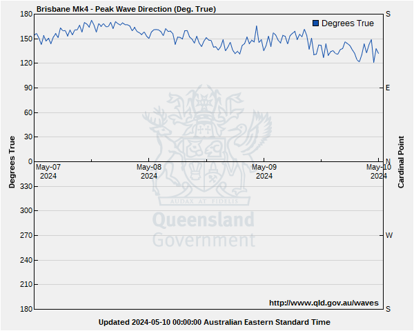
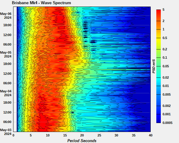
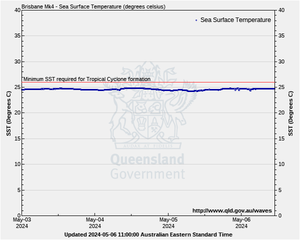
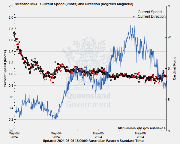
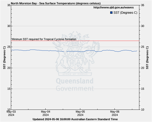
Moreton Bay Wave Buoys
Lat: 27° 29.230' S
Lon: 153° 37.900' E
Water depth: 70 m
Source: Queensland Government (Department of Environment, Science and Innovation).
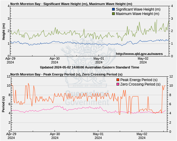
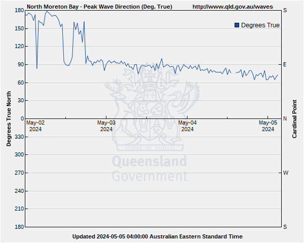
Wave height & period
On the Wave Height graph, the blue line shows the swell most indicative of what you will encounter in offshore waters
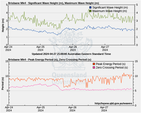
On the Peak Energy period graph which shows time between swells, the pink line is most indicative of what you will encounter in offshore waters
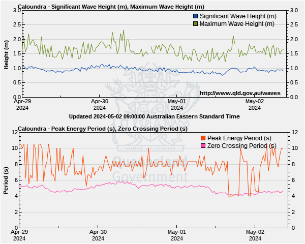
Lat: 26°53'54.6"S
Lon: 153°16'43.8"E
Water depth: 35 m
Source: Queensland Government (Department of Environment, Science and Innovation).
Wave height & period
On the Wave Height graph, the blue line shows the swell most indicative of what you will encounter in offshore waters
On the Peak Energy period graph which shows time between swells, the pink line is most indicative of what you will encounter in offshore waters


Lat: 26°50'51.3"S
Lon: 153°09'20.4"E
Water depth: 12 m
Source: Queensland Government (Department of Environment, Science and Innovation).
Wave height & period
On the Wave Height graph, the blue line shows the swell most indicative of what you will encounter in offshore waters
On the Peak Energy period graph which shows time between swells, the pink line is most indicative of what you will encounter in offshore waters


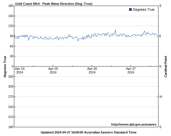
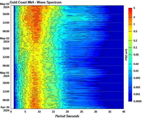
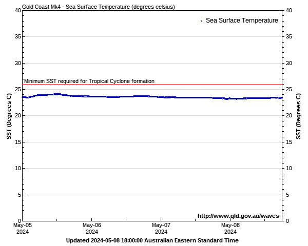
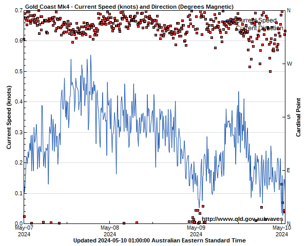
Lat: 27°57'54.8"S
Lon: 153°26'33.3"E
Water depth: 17 m
Source: Queensland Government (Department of Environment, Science and Innovation).
Wave height & period
On the Wave Height graph, the blue line shows the swell most indicative of what you will encounter in offshore waters
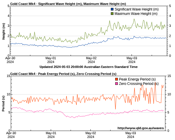
On the Peak Energy period graph which shows time between swells, the pink line is most indicative of what you will encounter in offshore waters