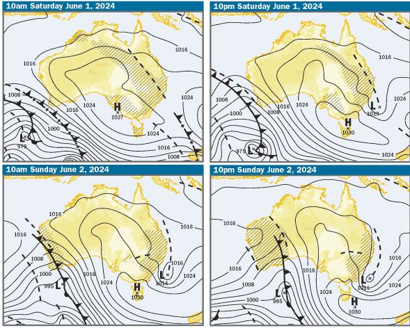
Issued at 5.30pm 30th May for 1st & 2nd June 2024
Charts: The charts are indicating that on Saturday, we will be on the back end of a high pressure system centred in the Tasman Sea near New Zealand and a trough laying along the NSW coast and extending into inland Qld. On Saturday night it looks like the trough has moved east and in the process of crossing the central and southern Qld coast. On Sunday morning, the trough looks like it will be just off the coast and then continue to move east through the day.
SE Qld Weather Outlook Saturday – Offshore Waters Double Island Point to Coolangatta
Based on the charts and BOM forecasts, on Saturday, in offshore waters north of Cape Moreton. winds should be 15-20kts N/NE, gusting to 25kts in the morning, swinging N/NW at 15-20ks during the day. In offshore waters south of Cape Moreton, winds should be 15-25kts Northerly, turning NW at 15-20kts in the evening. A high chance of rain and storms is predicted in both areas.
SE Qld Weather Outlook Sunday – Offshore Waters Double Island Point to Coolangatta
Winds are predicted to be 15-20kts NW early, swinging W/SW at 10 to 15 knots during the morning. A high chance of showers and storms is predicted
SE Qld Weather Outlook Saturday – Moreton Bay
Winds are predicted to be 10-15kts Northerly, becoming variable about 10 knots in the late afternoon, with a high chance of rain
SE Qld Weather Outlook Sunday – Moreton Bay
Winds are predicted to be 10-15kts Westerly in the morning, decreasing to about 10kts during the day, then increasing to 10-15kts during the evening, with a medium to high chance of showers and storms in the morning, clearing or decreasing during the day.
Tides & Moon: It’ll be last quarter or half moon down tomorrow night, so tidal differences are smaller over the next week. On the weekend, at Brisbane Bar cutting at the mouth of the Brisbane River, there’ll be early morning and late afternoon highs and lows in the middle of day. Click this link for precise tide times and heights at various locations
Swell & Coastal Bars: The swell looks likely to be about 1m NE on the weekend. If you are going offshore, as always, take care crossing bars, particularly on the morning ebb tides, when the water running out through narrow bar channels can create pressure waves, which are bigger than swell size and break unpredictably
Sailing & Boating: Based on the weather predictions, with rain predicted Saturday and showers on Sunday, it’ll be a good idea to take wet weather gear. There’ll be plenty of wind for sailing and boating conditions in offshore and open Moreton Bay waters, look like they’ll be better on Sunday than Saturday. As usual, the best cruising and anchorages will be in the sheltered waters from Caloundra to Donnybrook in Pumicestone Passage, the southern bay from Peel Island to the northern parts of Southport Broadwater and in the rivers and creeks
Fishing: On Saturday, it’s looking like conditions for fishing in offshore and open Moreton Bay waters will be very choppy to rough. On Sunday, it should still be choppy but better. The predicted Westerly winds will be good for beach fishing and the close inshore in the western parts of Moreton Bay, Pumicestone Passage, the southern bay and the rivers and creeks will offer best conditions for small boat fishing. To help you plan your weekend angling, the latest SE Qld Fishing Report was published on the Coastwatch web site this afternoon
Surf: Expect the swell to be about 1m NE. On Saturday, with predicted Northerly winds, the best waves should be on the south side of headlands and Southport Spit. On Sunday, with westerlies predicted, the best waves will be on the beach breaks on the open beaches. You can check the latest surf conditions with the daily Surf Report published about 5.50 every morning
Beach: Predictions of rain and showers on both days, is not a good outlook for going to the beach. On Saturday in the predicted Northerlies, the best shelter from the wind will be at Sunshine Beach, Kawana, Kings Beach Caloundra and Southport Spit to Surfers Paradise. On Sunday, with Westerly winds predicted, the open stretches of beach will be best, but the wind could chilly. There’s inshore holes and gutters along those open stretches and on the morning ebb tides, any rips working around those features will be enhanced as the water drains off the beach, so swim in the patrolled areas marked by the red and yellow flags. For the latest beach conditions, check our daily Beach Report published about 5.40 every morning

More Articles
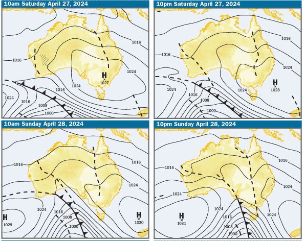
Issued at 5.15pm 25th April for 27th & 28th April 2024
Charts: The charts and weather models are indicating that there’ll be a large high pressure system centred over Victoria on Saturday morning, moving into the...
WEEKEND COASTAL WEATHER FOR 14th, 15th, 16th November 2025. ISSUED THURSDAY 13th November at 6.30pm .
It’s shaping up to be a stormy and unsettled weekend across the coast. Severe thunderstorms are forecast Friday afternoon and evening, with the most significant activity expected Saturday afternoon ...
COASTAL WEATHER OUTLOOK for Qld — March 6th, 7th, 8th 2026
Issued 6:45pm, March 5th. A turbulent few days are ahead for much of the Queensland coastline, with a developing tropical low, strengthening troughs, and shifting wind patterns shaping conditions ...