Issued at 5.10pm 6th June for 8th & 9th June 2024
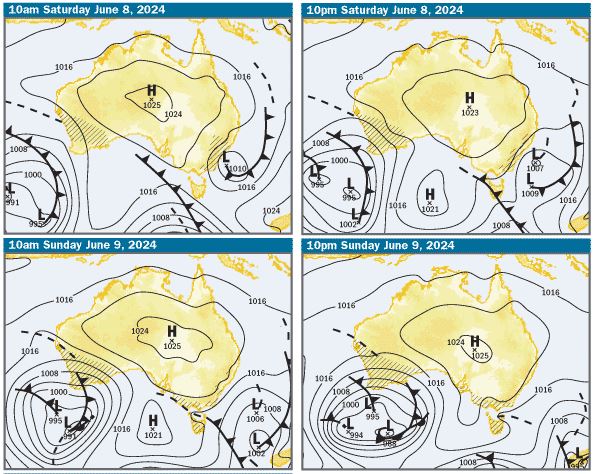
Charts: The charts are indicating a typical winter pattern, with a weak high over the middle of the country extending a weak ridge along the Qld coast and a series of troughs and lows moving eastwards to the south. There is a trough well off the southern and central Qld coasts, which looks like moving slowly east over the weekend
SE Qld Weather Outlook Saturday & Sunday – Offshore Waters Double Island Point to Coolangatta
Mostly Sunny both days, with winds predicted to be 10-15kts W/SW, reaching 15-20kts at times and possibly easing to about 10kts off the Gold Coast on Sunday afternoon
SE Qld Weather Outlook Saturday & Sunday – Moreton Bay
It should be a mostly sunny both days, with winds predicted to be W/SW about 10-15kts in the mornings in open northern and eastern bay waters and a bit lighter close inshore in Pumicestone Passage and the western and southern bay. They might ease a bit in the afternoons and swing NE, as the sea breeze effect kicks in.
Tides & Moon: It’s new or no moon tonight, so tidal differences are quite big for the next few days, with the biggest high tides at night. On the weekend, at Brisbane Bar cutting at the mouth of the Brisbane River, there’ll be early morning and late afternoon lows and highs mid to late morning and late at night. Click this link for precise tide times and heights at various locations
Swell & Coastal Bars: The swell looks likely to be 0.5-0.75m Easterly or E/SE on the weekend. If you are going offshore, although they should be workable, take care crossing bars, particularly on the afternoon ebb tides, when the water running out through narrow bar channels can create pressure waves, which are bigger than swell size and break unpredictably
Sailing & Boating: There’ll be nice winds for sailing, particularly in the mornings. Boating conditions in offshore waters will be very choppy and not comfortable in small boats, but will improve on Sunday afternoon off the Gold Coast, if the winds ease as forecast. Conditions should be better close inshore, where the wind should be lighter.
On Moreton Bay, expect seas to be choppy in open northern and eastern waters and much better close inshore and the best cruising and anchorages will be in the more sheltered waters in the western bay, Pumicestone Passage, the southern bay, Southport Broadwater and in the rivers and creeks
Fishing: Based on the weather predictions, it’s looking like conditions for fishing in offshore and open Moreton Bay waters will be very choppy to rough and choppy in open bay waters The predicted W/SW winds will be good for beach fishing and the more sheltered waters in the western bay, Pumicestone Passage, the southern bay, Southport Broadwater and in the rivers and creeks will be best for small boat fishing. To help you plan your weekend angling, the latest SE Qld Fishing Report was published on the Coastwatch web site this afternoon
Surf: Expect the swell to be really small, about 0.5m E/SE on the weekend and with W/SW winds predicted, the best chance of finding a few little waves, would be to hunt for beach breaks on the open beaches. If the winds swing light NE in afternoons as they have been doing lately, wave quality will deteriorate. You can check the latest surf conditions with the daily Surf Report published about 5.55 every morning
Beach: A cool, mostly sunny weekend is expected. The forecast air temperature is 21-22° and water temperature is about the same. Most beaches will be OK, but there will be some wind chill factor, so finding a spot against the dunes where there’s less wind would be a good idea. There’s inshore holes and gutters along the open stretches of beach and any rips and sweep working around them, will be enhanced as the water drains off the beach on the mid morning to mid afternoon ebb tides, so despite the small swell, swim in the patrolled areas marked by the red and yellow flags. For the latest beach conditions, check our daily Beach Report published about 5.55 every morning

More Articles
COASTAL WEATHER OUTLOOK for South East Qld — February 12th
Issued 9pm Thursday February 12th. Wet Conditions Ahead -- Heavy Rain and Severe Storms Expected This Weekend. Southeast Queensland is set for a very damp weekend as a series of low‑...
Issued at 4.30pm 7th March 2024 for Saturday 9th & Sunday 10th March 2024
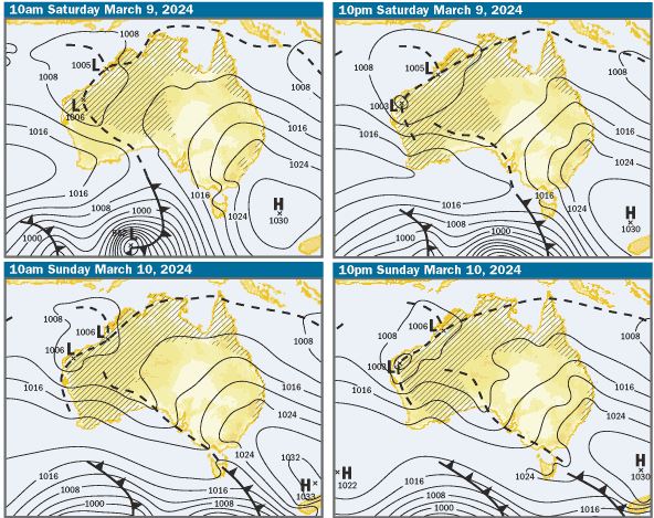
Charts: The charts and weather models are indicating that a strong high will be in the Tasman Sea this weekend, extending a firm ridge along the Qld Coast. There’s......
Issued at 5.15pm 25th April for 27th & 28th April 2024
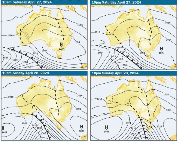
Charts: The charts and weather models are indicating that there’ll be a large high pressure system centred over Victoria on Saturday morning, moving into the...