Byron Coast
Byron Coastal Waters: Point Danger to Wooli Forecast
By the Bureau of Meteorology
Today’s weather chart

Byron Coastal Waters: Point Danger to Wooli Forecast
By the Bureau of Meteorology
A weak high pressure system off the New South Wales coast is maintaining mostly light winds along the state's waters. This pattern will bring a moderate to fresh westerly change to southern and central waters today before heading to the northern coast as a southerly change on Thursday. Winds will weaken as another high pressure system drifts across the state later in the week. Then the next cold front looks set to cross the state during the weekend.
Forecast issued at 02:21 am EST on Wednesday 26 June 2024.
Warnings Current
Warning to Sheep Graziers for Southern Tablelands and Snowy Mountains forecast districts
IDN29000
Australian Government Bureau of Meteorology
New South Wales
Warning to Sheep Graziers
Issued at 11:08 AM EST on Wednesday 26 Jun 2024.
Sheep graziers are warned that cold temperatures, showers and westerly winds are expected during Wednesday and Thursday. Areas likely to be affected include parts of the Southern Tablelands and Snowy Mountains forecast districts. There is a risk of losses of lambs and sheep exposed to these conditions.
The Warning to Sheep Graziers for the Illawarra and South Coast forecast districts has been cancelled.
The next warning will be issued by 5:00 pm EST Wednesday.
Severe Weather Warning for parts of Snowy Mountains Forecast District.
IDN21037
Australian Government Bureau of Meteorology
New South Wales
Severe Weather Warning
Issued at 10:53 AM EST on Wednesday 26 Jun 2024.
Weather Situation

Damaging winds redeveloping over alpine areas from late this morning.
Weather Situation: A vigorous west to northwesterly flow over southern New South Wales will result in damaging winds redeveloping from late this morning, then easing from Thursday morning as a high approaches from the west.
DAMAGING WINDS averaging 80 to 90 km/h with peak gusts of around 110 km/h are likely over alpine areas above 1900 metres from late this morning.
Winds are forecast to ease below warning thresholds by late Thursday morning.
Locations which may be affected include Thredbo Top Station.
Severe weather is no longer occurring in the South West Slopes district and the warning for this district is CANCELLED.
Thredbo recorded winds around 80 to 85 km/h during periods between 12:00 pm and 6:00 pm on Tuesday.
The State Emergency Service advises that people should:
- * Move vehicles under cover or away from trees.
- * Secure or put away loose items around your house, yard and balcony.
- * Keep at least 8 metres away from fallen power lines or objects that may be energised, such as fences.
- * Trees that have been damaged by fire are likely to be more unstable and more likely to fall.
- * Report fallen power lines to either Ausgrid (131 388), Endeavour Energy (131 003), Essential Energy (132 080) or Evoenergy (131 093) as shown on your power bill.
- * Stay vigilant and monitor conditions. Note that the landscape may have changed following bushfires.
- * For emergency help in floods and storms, ring your local SES Unit on 132 500.
Warnings are also available through TV and Radio broadcasts, the Bureau's website at www.bom.gov.au or call 1300 659 210. The Bureau and State Emergency Service would appreciate warnings being broadcast regularly.

Forecast for Wednesday until midnight
| Wind | North to northwesterly 10 to 15 knots. |
| Seas | Below 1 metre. |
| Swell | Easterly below 1 metre. |
| Weather | Mostly sunny. The chance of a thunderstorm offshore south of Yamba. |
Thursday 27 June
| Wind | North to northwesterly 10 to 15 knots tending west to northwesterly early in the morning then becoming variable below 10 knots in the early afternoon. |
| Seas | Below 1 metre. |
| Swell | Easterly below 1 metre. |
| Weather | Partly cloudy. 70% chance of showers. The chance of a thunderstorm. |
Friday 28 June
| Wind | Southerly 10 to 15 knots turning southeasterly 15 to 20 knots during the day. |
| Seas | Below 1 metre, increasing to 1 to 1.5 metres north of Yamba during the morning. |
| Swell | Easterly below 1 metre. |
| Weather | Partly cloudy. 60% chance of showers. |
Current Weather
Latest BOM Weather Stations Data
Anemometer Location: Lat -28.64 Lon 153.636. 95 m above sea level.
- Wind NE 5kts
- Gusts 6kts
- Temp 19.9°C
- Rain 15:20pm 1.2mm
Anemometer Location: Lat -28.835 Lon 153.559. 1.3 m above sea level.
- Wind NE 7kts
- Gusts 8kts
- Temp 20.3°C
- Rain 15:20pm 0mm
Anemometer Location: Lat -28.83 Lon 153.26. 9.21 m above sea level.
- Wind NE 5kts
- Gusts 5kts
- Temp 21.5°C
- Rain 15:20pm 0mm
Anemometer Location: Lat -28.168 Lon 153.505, Airport. 1 m above sea level. 6km from coast.
- Wind N 10kts
- Gusts 11kts
- Temp 22.1°C
- Rain 15:20pm 0mm
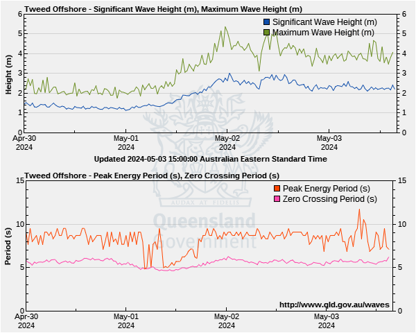
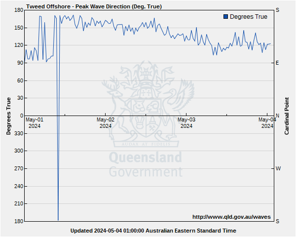
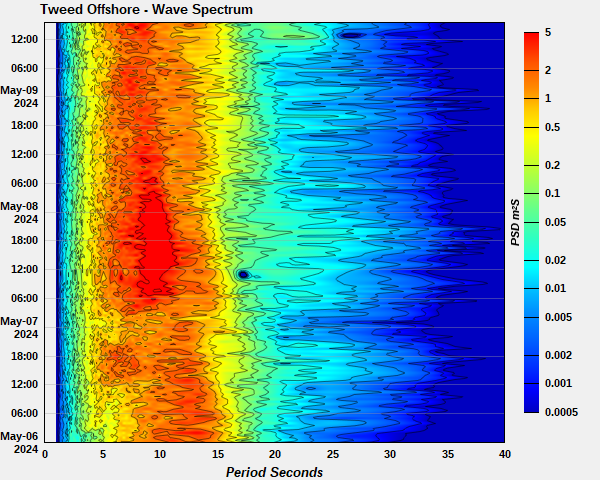
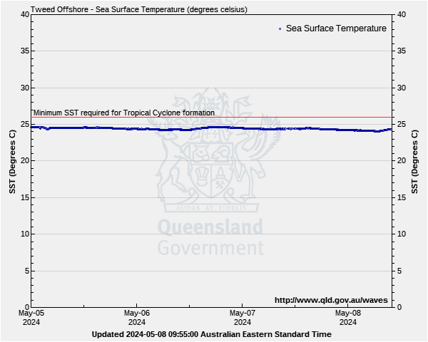
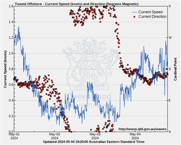
Byron Coastal Waters: Point Danger to Wooli Wave Buoys
Lat: 28°10'39.3"S
Lon: 153°34'35.6"E
Water depth: 22 m
Source: Queensland Government (Department of Environment, Science and Innovation).
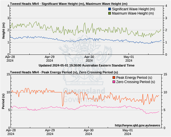
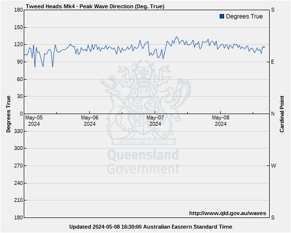
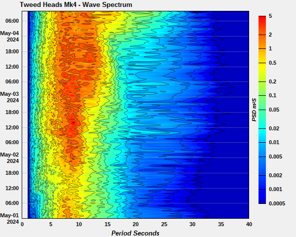
Lat: 28°12'45.2"S
Lon: 153°40'48.6"E
Water depth: 60 m
Source: Queensland Government (Department of Environment, Science and Innovation).